
ROMAN FRONTIER · IMPERIAL PERIOD
Roman Iron Arrowhead I
ONE IRON ARROWHEAD · 10-INCH DISPLAY
£74.95
Along the Danube, Roman garrisons, traders and families made a life beside a formidable river frontier. Journey through Noricum and Pannonia before discovering our framed iron-arrowhead collection.
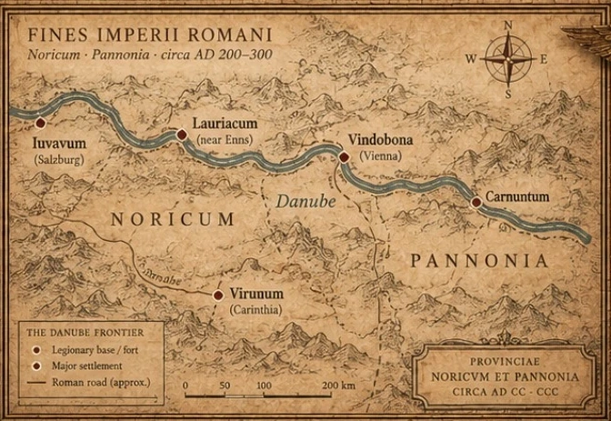 NORICUM · PANNONIA · THE DANUBE ENLARGE MAP ↗
The Roman frontier was not simply a line on a map. It was a living landscape of forts, towns, roads and river crossings.
READ THE STORY ↓Five individually framed iron-arrowhead displays, inspired by the military and provincial world of the Danube.
05 SINGLE EXHIBITSONE IRON ARROWHEAD · 10-INCH DISPLAY
ONE IRON ARROWHEAD · 10-INCH DISPLAY
ONE IRON ARROWHEAD · 10-INCH DISPLAY
ONE IRON ARROWHEAD · 10-INCH DISPLAY
ONE IRON ARROWHEAD · 10-INCH DISPLAY
Around AD 200–300, the Danube was one of Rome’s defining northern boundaries. Fortified positions at places such as Lauriacum, Vindobona and Carnuntum helped control movement through a frontier shared by soldiers, merchants, craftspeople and families. Roman roads, river traffic and settlements stitched these communities together.
Noricum and Pannonia encompassed parts of modern-day Austria and the neighbouring Danube lands. The frontier forts, Roman roads and trading settlements shown on our map offer a window into the world in which iron arrowheads of this type were used.
Each iron point is being individually mounted against a crisp white recessed mount, allowing its distinctive shape, weathered surface and craftsmanship to take centre stage. Together, the five pieces form our first Roman Frontier Collection.
The seller described these as Roman-period iron arrowheads from an Austrian region, approximately AD 200–300. These are seller attributions; no documented archaeological findspot accompanied the group.
The collection is being prepared for release. Final exhibit photographs will accompany each listing.